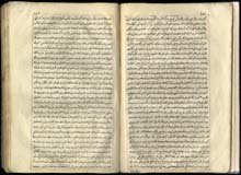
printed surface: 125×240 mm;
page: 190×300 mm;
lines: 31;
copies: 500.
The Cihânnümâ (“Book of the World”)
was the most state of art summary of the Ottoman geographical knowledge
of the age. The reason was that the author heavily relied, for the very
first time, on European sources, such as Mercator’s famous Atlas
Minor. The first part of the work is dedicated to overall geography
and hydrography, and the second to the political geography, road network
and hydrography of the continents, including America and Australia.
The printed edition was in fact an extended version of the work,
containing several additions – including the appendix of Müteferrika (pp. 422-698) –
which doubled its original size.
The geographical work by
Kâtib Çelebi was ready for print already in 1730, but its publication –
for unclear reasons, but probably also due to the priorities of the
press changed by the new political conditions – was late, and it was
preceded by Müteferrika’s two own works as well as by Holdermann 's
grammar. According to its preface, it was Grand Mufti Dâmâdzâde Mevlânâ Şeyh Ahmed
who suggested the publication of the work to
Müteferrika, but by taking into account the period of the Grand Mufti’s
office (February 1732 – October 1733), this may have not inspired, only
reinforced the earlier dedication of the printer. It is also possible
that Müteferrika had feared an eventual disapproval of the religious
scholars because of the publisher’s appendix on the Copernican
heliocentric world.
A fragment of the work, devoid of all illustrations and maps, can be
found in the Oriental Collection [MTAK shelfmark: 770.154],
while a full copy in good conditions in the National Széchényi Library [OSZK shelfmark:
H 3142].
 |
||||
| 151v-152r |


